Image:
Torrential downpours have battered many parts of Italy this month, with extreme flooding wreaking havoc across northern Italy. The province of Alessandria is said to be one of the worst-affected areas according to Italian media, with around 200 people evacuated and 600 said to be left stranded.
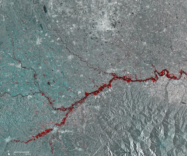
This multi-temporal image uses two separate images captured by the Copernicus Sentinel-1 mission on 13 November and 25 November. The flooded areas can be seen depicted in red, the Po River in black, and urban areas in white.
Copernicus Sentinel-1’s radar ability to ‘see’ through clouds and rain, and in darkness, makes it particularly useful for monitoring floods. It can even easily differentiate water bodies, highlighting the difference between the Po River in black, and the extent of the flooding in red.
Around 500 people were evacuated further north in the Aosta Valley, where many roads were closed in fear of potential avalanches. Part of a viaduct serving the A6 motorway near Savona, in the northern region of Liguria, was washed away by a mudslide – leaving a 30 m gap in the road.
Images acquired before and after flooding offer immediate information on the extent of inundation and support assessments of property and environmental damage.
Earlier this month, the Copernicus Emergency Mapping Service was activated to help respond to the floods in northeast Italy, where Venice saw record-breaking water levels and the worst flooding in 50 years.
Comments are closed.