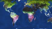
Billions of image pixels recorded by the Copernicus Sentinel-2 mission have been used to generate a high-resolution map of land-cover dynamics across Earth’s landmasses. This map also depicts the month of the peak of vegetation and gives new insight into land productivity.
Comments are closed.