Image:
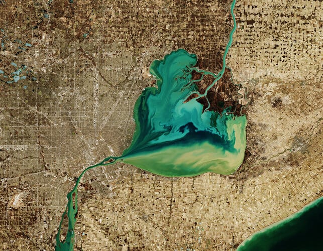
The Copernicus Sentinel-2 mission takes us over Lake St. Clair, forming the border between Ontario, Canada to the east, and Michigan, US to the west.
The Saint Clair River is visible at the top of the image and flows southwards, connecting the southern end of Lake Huron with Lake St. Clair, visible in the centre of the image. The river branches into several channels before reaching the lake, creating a seven-mouth delta. Much of the area surrounding the delta is used for agriculture.
The Thames River, visible east of the lake, begins in a swampy area of Ontario, before emptying its muddy waters into Lake St. Clair. Here the murky-coloured waters mix with the turquoise waters from the Saint Clair River, creating this fusion of colour visible in the heart-shaped lake. The waters then exit the lake via the Detroit River.
Lake St. Clair is approximately 40 km long and 40 km wide, with an average depth of around 3 metres. The lake is a popular site for fishing and boating, and more than 100 species of fish inhabit the lake including walleye, rainbow trout and muskellunge.
Detroit, the largest city in Michigan, is visible directly above the Detroit River. The city lies on a relatively flat plain and its extensive network of roads in the city are clearly visible in the image.
Detroit is nicknamed the “motor city” as it was the key hub for American auto-manufacturing for over a century. It was also home to the first mile of concrete highway, the first four-way three-colour traffic light and the world’s first urban freeway.
In this wintery image, captured on 26 March 2019, many of the frozen lakes northwest of the lake can be seen partially frozen over. The Copernicus Sentinel-2 mission allows inland bodies of water to be closely monitored.
This image is also featured on the Earth from Space video programme .
Comments are closed.