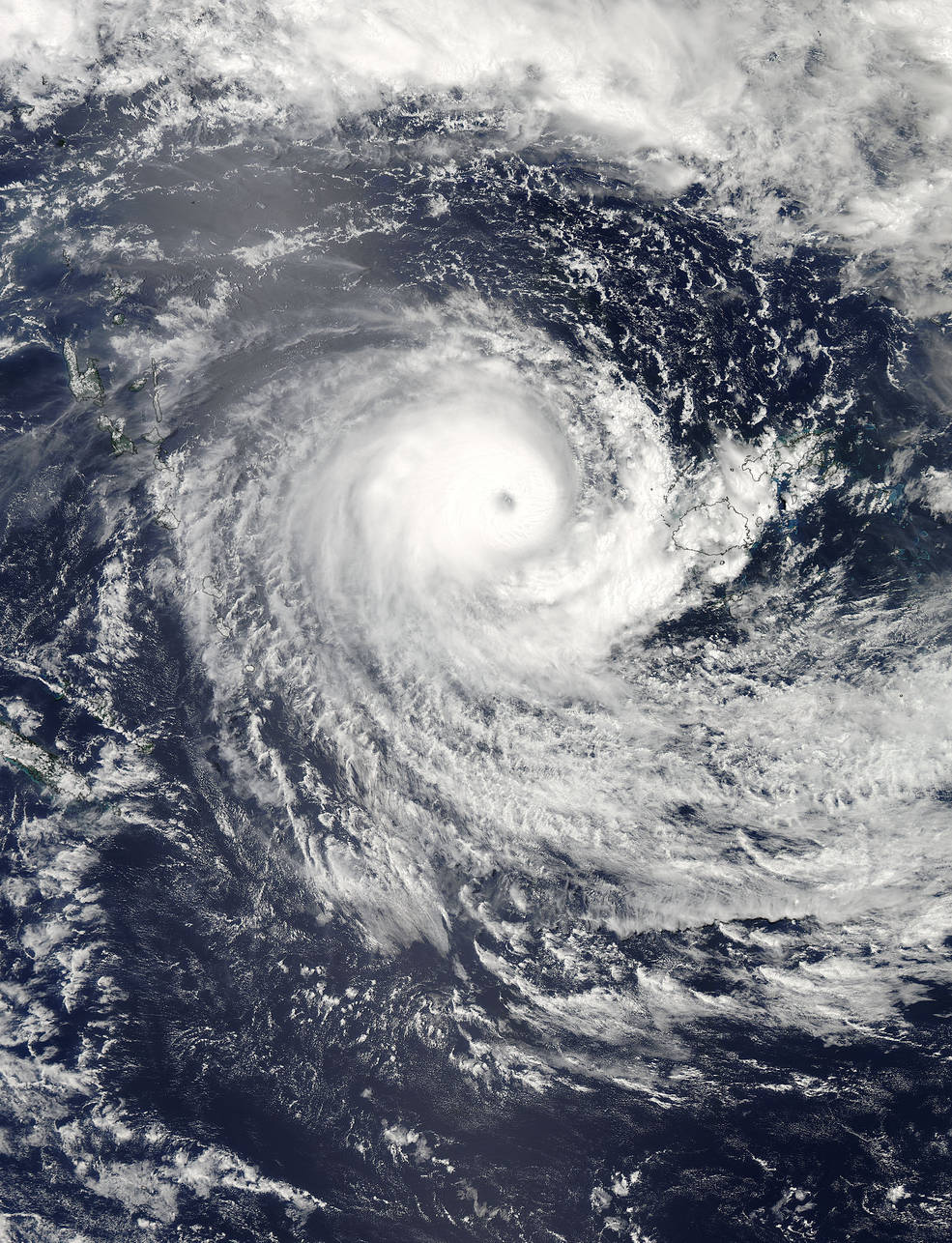
%20NASA's%20Aqua%20satellite%20captured%20this%20visible%20image%20of%20Tropical%20Cyclone%20Winston%20in%20the%20South%20Pacific%20Ocean,%20west%20of%20Fiji.)
On Feb. 21, 2016, at 02:15 UTC (Feb. 20 at 9:15 p.m. EST) NASA’s Aqua satellite captured this visible image of Tropical Cyclone Winston in the South Pacific Ocean, west of Fiji.
Credit: NASA Goddard MODIS Rapid Response Team/Jeff Schmaltz
Satellite photos give a bird’s-eye view of Tropical Cyclone Winston, the powerful storm that battered the Pacific Island nation of Fiji over the weekend.
NASA’s Aqua spacecraft captured an image of Winston on Saturday (Feb. 20), the day the maelstrom made landfall on the island of Vitu Levi as a Category 5 storm — the most powerful type on the Saffir-Simpson Hurricane Wind Scale. (Storms such as Winston are called hurricanes in the Atlantic and Northeast Pacific regions, typhoons in the North Pacific and cyclones throughout the South Pacific and Indian Ocean.)
The Fiji Meteorological Service estimated that wind gusts near Winston’s center topped 200 mph (322 km/h), NASA officials said. The storm is the strongest on record in the Southern Hemisphere, and it has caused more than two dozen deaths. (The toll is expected to rise as rescue workers and officials make their way to outlying parts of the Fiji archipelago, which consists of more than 300 individual islands.) [Hurricanes Seen From Space: Satellite Views ]
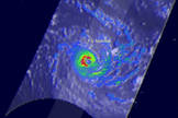

On Feb. 20, 2016, at 0941 UTC (4:41 a.m. EST), the NASA/JAXA GPM core satellite saw that Winston was dropping rain at a rate of over 169 mm (6.7 inches) per hour in the western side of the eye.
Credit: NASA/JAXA/Hal Pierce
The Global Precipitation Measurement core observatory satellite , a joint mission involving NASA and the Japan Aerospace Exploration Agency (JAXA), flew directly over Winston early Saturday morning. Analysis of the spacecraft’s measurements, along with other data, allowed scientists to estimate that the cyclone was dumping 6.7 inches (17 centimeters) of rain per hour in locations along the western side of its eye, NASA officials said.
On Sunday night (Feb. 21), an instrument aboard the Suomi NPP satellite, which is jointly operated by NASA and the U.S. National Oceanic and Atmospheric Administration, captured an image of Winston churning in the warm seas between Vanuatu and Fiji.
The storm was weakening at the time; wind speeds were dropping, and Winston’s 23-mile-wide (37 km) eye was filled with clouds.
By 10 a.m. EST (1500 GMT) on Sunday, “Winston’s maximum sustained winds dropped to 90 knots (103.6 mph/166.7 kph), making it a Category 2 hurricane,” NASA officials wrote in an update .
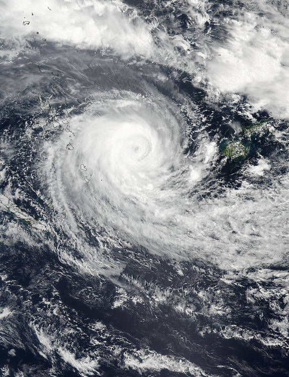

On Feb. 21, 2016 at 9:00 p.m. EST, the VIIRS instrument aboard NASA-NOAA’s Suomi NPP satellite captured this visible image of Tropical Cyclone Winston between Vanuatu (left) and Fiji (right).
Credit: NASA/NOAA
“Scatterometry satellite data showed that the hurricane-force winds extend 30 nautical miles (34 miles/55 km) from the center,” they added. “It was located about 348 nautical miles (400.5 miles/644.5 km) west of Suva, Fiji near 18.2 degrees south latitude and 172.3 degrees east longitude. Winston was moving to the south slowly at 3 knots (3.4 mph/5.5 kph).”
Winston will weaken as it moves farther south. The cyclone should leave the tropics (which are bounded by the Tropic of Cancer north of the equator and the Tropic of Capricorn south of the equator) near New Caledonia, NASA officials added.
Follow Mike Wall on Twitter @michaeldwall and Google+ . Follow us @Spacedotcom , Facebook or Google+ . Originally published on Space.com .
Comments are closed.