Video: 00:02:50 Priya Patel, System Engineer, talks about her experience as a YGT working on the Laser Interferometer Space Antenna Mission (LISA) . To source


Video: 00:02:50 Priya Patel, System Engineer, talks about her experience as a YGT working on the Laser Interferometer Space Antenna Mission (LISA) . To source

Video: 00:10:05 ESA’s flight controllers use the best software and systems to fly our missions — but do they have the cool savvy needed to handle a wonky engine and a time-critical manoeuvre? Set in the near future, ‘The Burn’ is a new short film that tells the story of what happens when an ESA […]

Video: 00:01:01 The latest Harris Interactive survey conducted on behalf of ESA reveals out-of-this-world aspirations for European citizens when it comes to space activities. Find out more in this short video, and look out for the full report – coming soon! To source

Image: The Cheops satellite positioned onto the fuelling stand at Europe’s spaceport in Kourou, French Guiana. The stand facilitates access to the propulsion module, easing fuelling activities. To source

Where the two hemispheres of Mars meet, the planet is covered in broken-up terrain: a sign that slow-but-steady flows of icy material once forged their way through the landscape, carving out a fractured web of valleys, cliffs and isolated mounds of rock. To source

Image: This image from ESA’s Mars Express shows a region of Mars named Deuteronilus Mensae. This oblique perspective view was generated using a digital terrain model and Mars Express data gathered on 25 February 2018 during orbit 17913. The ground resolution is approximately 13 m/pixel and the images are centred at about 25.5°E/44°N. This image […]

Image: This colour-coded topographic view shows a region of Mars named Deuteronilus Mensae. Lower parts of the surface are shown in blues and purples, while higher altitude regions show up in whites, yellows and reds, as indicated on the scale to the top right. This view is based on a digital terrain model of the […]

Quick reference: ESA’s vision and goals for Space19+ To source

Image: The Cheops satellite during transfer from building S5C to the payload facility of S5A through the internal corridor, as part of launch preparations at Europe’s spaceport in Kourou, French Guyana. The satellite is being moved on its multi-purpose trolley under the supervision of Airbus staff and with the support of the spaceport team. During all phases, a […]

Image: The first spacewalk to service the Alpha Magnetic Spectrometer (AMS) could not have gone better. Lead spacewalker ESA astronaut Luca Parmitano is imaged here hitching a ride on the International Space Station’s 16-metre long robotic arm to kick off the first of four ventures to service the particle physics detector on 15 November. While […]

A recent ‘deep learning’ algorithm – despite having no innate knowledge of solar physics – could provide more accurate predictions of how the Sun affects our planet than current models based on scientific understanding. To source

Data from ESA’s Cluster mission has provided a recording of the eerie ‘song’ that Earth sings when it is hit by a solar storm. To source

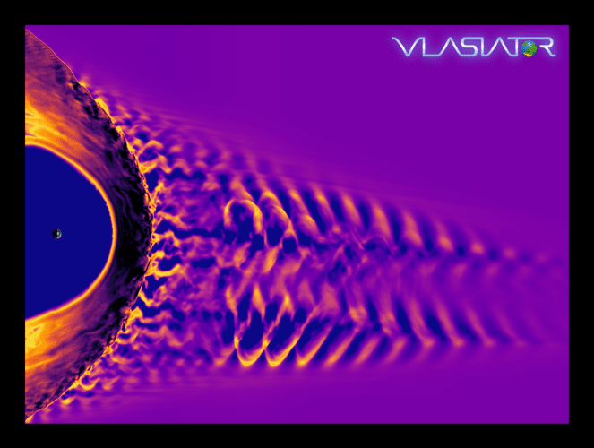
Image: In this image, Earth is the dot to the left of the image and the large arc around it is our planet’s magnetic bow shock. The swirling pattern to the right is the foreshock region where the solar wind breaks into waves as it encounters reflected particles from the bow shock. The image was […]